Embedded Files
Where are Tom and Lennie Now? -Click Here For Our Current Location
The word for today was WOW!
The weather took a turn today, as we woke up in Montrose, Colorado to 47 degrees. Our only plan for today was to travel down the Million Dollar Highway, which is Route 550 through Ouray, Silverton, and Durango, Colorado. It covers 3 high elevation mountain passes. This high elevation route covers about 70 miles. Once back down in Durango, we planned to head east to Pagosa Springs, Colorado for the night.
The radar showed rain showers and possible thunderstorms that kept popping up south of Durango, and working their way toward us in the north. By the time we packed the trailer and hit the road, the rain had started falling. It looked like it was going to be a wet ride all the way to Durango. Little did we know.
Lennie and I had traversed the Million Dollar Highway on our trip out west last year. It has some magnificent views, but you do need to be careful. The highway was actually covered recently on a TV show on the Speed channel, called Dangerous Drives. The high elevation, steep cliffs, lack of shoulders and guardrails, mean you have to pay attention. In the winter, snowplow drivers have actually been swept off the road and down the cliffs by snow slides. Rock slides in the summer can also be an issue.
Here is a link to the TV episode on HULU...
Dangerous Drives - The Million Dollar Highway
The three mountain passes traversed by this roadway are...
Red Mountain Pass - 11,018 ft
Molas Pass - 10,970 ft
Coal Bank Pass - 10,640 ft
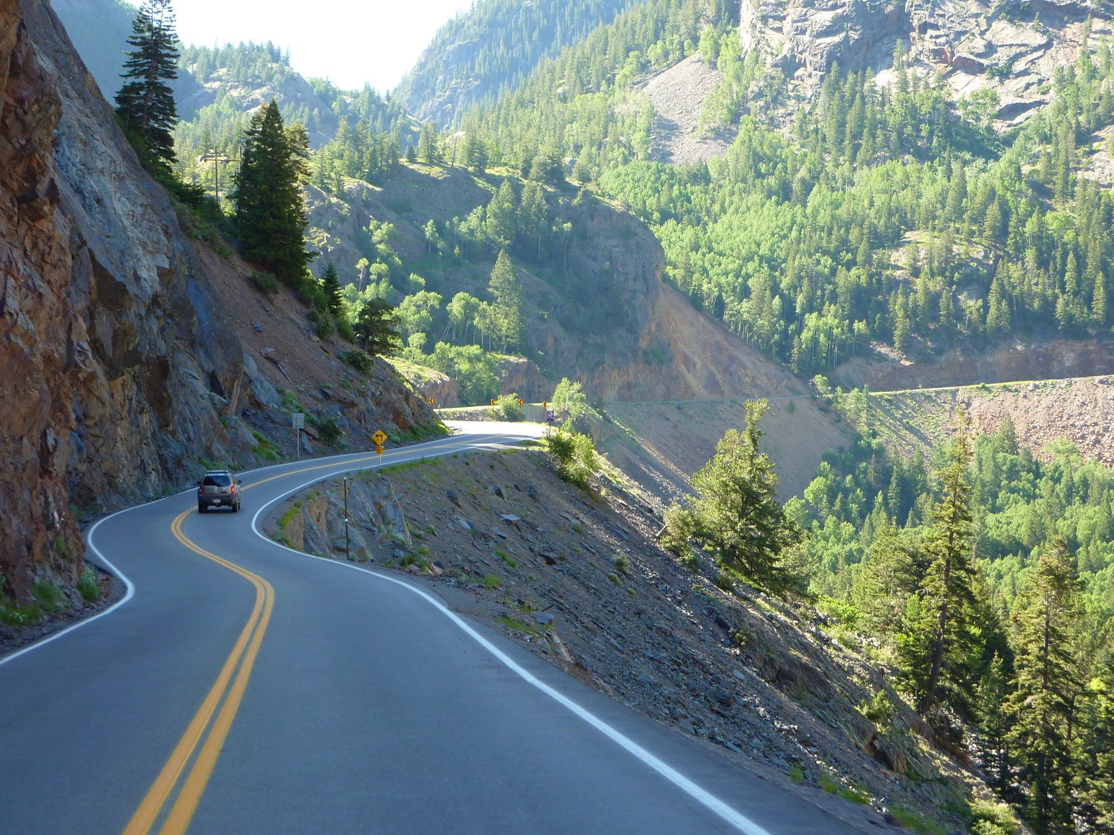
Below is a photo from our trip last year. This is a relatively flat area of the pass, but you can see just how narrow the road is. Note, that once you hit that white stripe, you only have a foot or so before you drop (no shoulders, no guardrails).
So, having set the stage a little :) Today's ride was nothing like the ride last year. We worked our way from Montrose down to Ouray with little more than a light rain. The climb up the first pass begins as you leave Ouray. We decided to do a quick radar check before heading up, and based on what we saw, we decided to stay put and eat lunch in Ouray. Once we finished lunch, the radar looked a little better, so off we went.
The first pass is Red Mountain, and as we headed up, the weather continued to deteriorate. At about 9000 feet, it was 38 degrees and we started to hit major fog. At 10,000 feet, the rain turned to snow!! It was snowing so heavily, that the bike windshield got completely covered, I could not see through it at all. It really didn't matter at this point, because the fog was so thick you couldn't see much anyways. I tried looking around the sides of the windshield, and Lennie sits up higher on the back seat, so she could see over the windshield. I kept an eye on the GPS screen to monitor the tight turns, and drove mostly by looking down and watching the white and yellow lines beside the bike, making sure I stayed between them. Lennie helped by yelling any time she saw a 10 mph, sharp turn ahead sign. Once you start the climb, there is really nowhere to turn around, so we trudged onward. A quick glance at the temperature gauge on the bike once we hit the crest showed 31 degrees !!! After several slow miles like this, we finally started to descend. Once we dropped back down to about 9000 feet, the snow stopped and the fog was much less dense. One peak tackled.
After the first peak, the road passes through the town of Silverton. We stopped there for gas, and the radar and skies to the south looked like they were improving. So, off we went for pass number two, Molas Pass. Molas Pass reaches over 10,000 feet as well, but as we climbed, we noticed much less fog, and no snow, instead we got hail !! It was only for a short time, and only for about a mile near the peak, but still,long enough and large enough to be annoying. Oh, I forgot to mention the thunder and lightning that went with the hail :) As we dropped back down to around 8500 feet, the thunder and lightning passed.
Now, on to the final pass before dropping down into Durango. Coal Bank Pass is the smallest of the three passes, but it still crests above 10,000 feet. This one turned out to be a cinch, weather wise. However, after cresting the peak and dropping down the southern side, we got a nice little scare of a different type. Standing on the side of the road was a huge mule deer. With the rain drizzle that was still falling, I never saw him until we were right next to him. He never moved, but looked at us as we passed, as if to say, what the hell are you doing out here on a bike in this weather?
Once down into Durango, the rain actually let up, and we had a nice ride for the remaining 50 miles to our hotel, albeit a little chilly.
It seems each trip, we have a day that marks the vacation, one we know we will always remember. Last year it was our off-road trek in dirt, gravel, and slickrock trails near Moab, on a motorcycle not equipped for that type of terrain. (If you missed that story last year, click on this link) This year, it was the crazy weather as we crested three high elevation passes in Colorado.
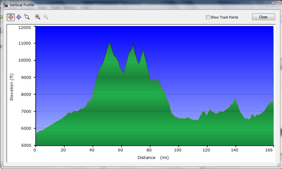
Below is a profile view of today's ride. Notice the three peaks? They may have names, but I remember them as...
Peak One - Snow, Fog, 31 degrees
Peak Two - Rain, Hail, Thunder, and Lightning
Peak Three -Crazy Mule Deer that scared the crap out of us
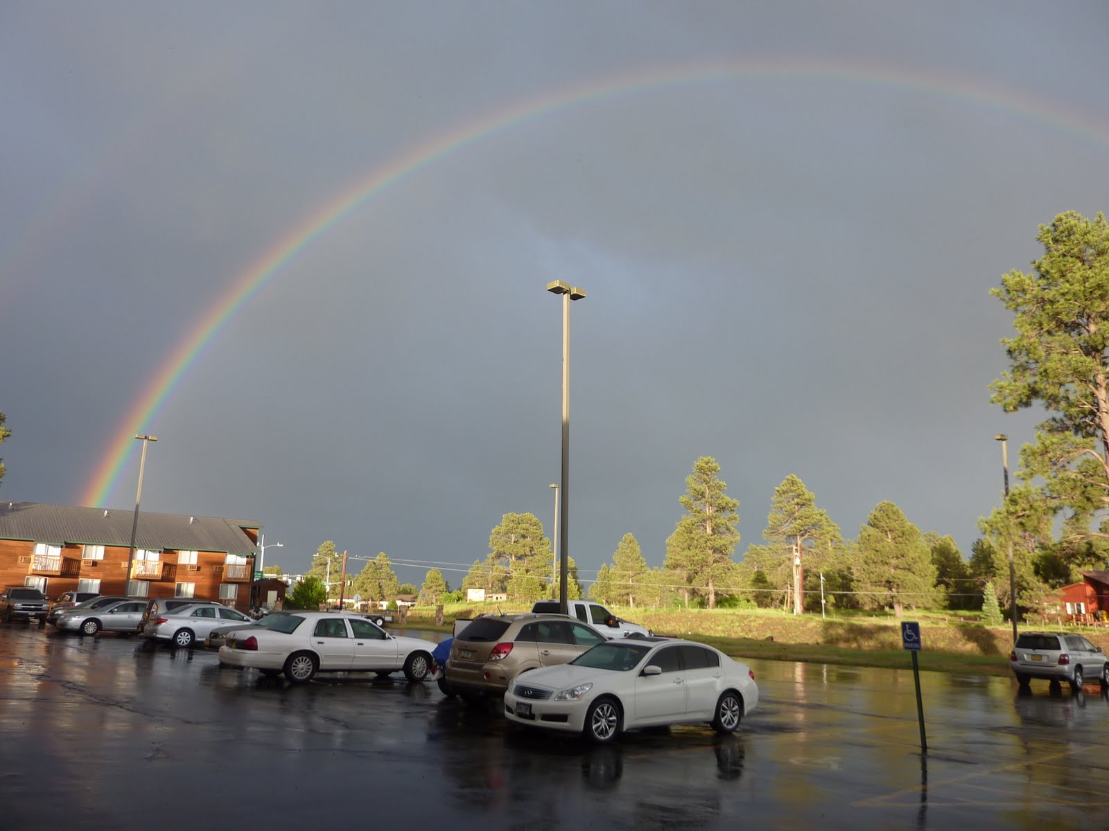
Here's a way to end the day. Once at our hotel, it rained for another couple of hours and then Lennie spotted this outside of our hotel window. She grabbed the camera and went out to the parking lot to take a picture. Perhaps a sign that someone was looking out for us today? All I can say, is that I am glad today's ride is done, it was only 166 miles in total, but I was exhausted once we arrived at the hotel.
Below is our route from today, we covered 166 miles, bringing our current trip total to 4519 miles.
Tomorrow, we are planning on riding south, into the mountains in northern New Mexico, and will end up in Santa Rosa for the night.
Google Sites
Report abuse